
Williamson County ZIP Code Coverage
These postal entries are a working guide to service areas in and around Williamson County. They draw from county and city maps plus Texas ZIP and district references. A ZIP boundary is a postal-delivery boundary, not a city or county boundary. Station names and PO-box designations were not published in one official county list, so the table identifies a station only where the local source supplied one and leaves uncertainty visible. Confirm a particular address with a USPS lookup before treating its ZIP as final.
| ZIP | Areas covered in or near Williamson County | Post office or station | Record-search note |
|---|---|---|---|
| 76511 | Bartlett and rural east or southeast county portions | Bartlett | County and city boundaries can differ. |
| 76527 | Florence and nearby northwest rural areas | Florence | Appears in state ZIP and district references. |
| 76530 | Granger and nearby eastern county | Granger | Postal area can cross rural and city limits. |
| 76537 | Jarrell and nearby north county | Jarrell | Verify newer subdivisions. |
| 76574 | Taylor and nearby east county | Taylor | City service area is not the ZIP polygon. |
| 76577 | Thrall and rural east-county area | Thrall | Boundary check is needed. |
| 76578 | Weir and nearby rural county | Weir | Exact boundary was not located in official sources. |
| 78613 | Cedar Park and northwest Austin-area county portions | Cedar Park | Mismatch is possible near a municipal line. |
| 78615 | Coupland and nearby southeast rural area | Coupland | Extends beyond the compact city place. |
| 78626 | Georgetown central and east areas with nearby county | Georgetown | Georgetown uses more than one ZIP. |
| 78627 | Georgetown post-office and rural northwest area | Georgetown | Small rural delivery area, verify situs. |
| 78628 | Georgetown west and northwest, including Andice-area references | Georgetown | Not a city-limit boundary. |
| 78633 | Georgetown north and senior-community area | Georgetown | Part of the multi-ZIP Georgetown service area. |
| 78634 | Hutto and rural northeast area | Hutto | Also appears in Round Rock research files. |
| 78641 | Leander and northwest Williamson County | Leander | Includes unincorporated county areas. |
| 78642 | Liberty Hill and nearby northwest county | Liberty Hill | City and ZIP may not match. |
| 78645 | Leander and lake-area county edge | Leander or Lago Vista area not located | Postal boundary crosses county and city context. |
| 78646 | North Austin technology-corridor county portions | Austin not located | May not be a Williamson city address. |
| 78653 | Southeast county edge near Manor and Pflugerville | Manor or Pflugerville not located | Do not equate with a Williamson city. |
| 78660 | Pflugerville and southeast Williamson portions | Pflugerville | County map and district data show a county portion. |
| 78664 | Round Rock west and central areas | Round Rock | Named in Round Rock official documents. |
| 78665 | Round Rock east and southeast areas | Round Rock | Named in Round Rock official documents. |
| 78680 | Round Rock post-office box or service area | Round Rock | Verify USPS designation for the address. |
| 78681 | Round Rock northwest areas | Round Rock | Named in Round Rock official documents. |
| 78682 | Round Rock southeast and postal service area | Round Rock | Postal boundary, not a city limit. |
| 78691 | Round Rock-area rural or service addresses | Round Rock not located | Exact county portion was not located. |
| 78717 | Austin postal area with a Williamson County edge | Austin | City, ZIP, and county can disagree. |
| 78728, 78729, 78758 | Southeast and west county-edge postal areas | Austin | Verify with county GIS and the postal address. |
Use this ZIP code directory as a routing tool, then let the specific address decide the next source. The county’s GIS Address Search and its Maps page are the local checks when a ZIP label, city name, and record jurisdiction point in different directions.
Williamson County ZIP Code Clusters
Georgetown alone illustrates why one city does not mean one ZIP. The county research identifies 78626, 78627, 78628, and 78633 in Georgetown’s service pattern. Round Rock has separate clusters at 78664, 78665, and 78681, plus postal service areas at 78680 and 78682. Cedar Park, Leander, Liberty Hill, Hutto, Taylor, Jarrell, Granger, Florence, Bartlett, Thrall, and Coupland each connect to other ZIP patterns. Rural and unincorporated territory often makes the difference sharper.
Rapid growth adds another reason to date the result. Census QuickFacts records 609,017 people in Williamson County in 2020 and a 752,827 estimate for July 1, 2025. New subdivisions, city expansion, and postal assignments can make a broad ZIP search less exact than a parcel or selected GIS address. Note: A ZIP narrows a search area, but it does not establish where an address falls for all county functions.
Williamson County Postal Jurisdictions
Postal geography sits beside, rather than inside, the county’s other local boundaries. Williamson County’s tax-rate directory includes city and county units, school districts, and other taxing jurisdictions for Georgetown, Round Rock, Taylor, Hutto, Jarrell, Liberty Hill, Florence, Granger, Leander, Coupland, and Thrall. A parcel can therefore have a county record, a city-style postal label, a separate school district, and an emergency-service zone at the same time. Keep each jurisdiction in its own field when comparing records.
This overlap is especially important near the Austin, Pflugerville, Manor, and lake-area edges. A place-name search may fail because the address is carried under another postal city. Search the street number and road name without the city, select the county GIS result, then compare the legal description and appraisal record. That approach follows the county’s addressing material instead of guessing from a ZIP label.
Search Williamson County by ZIP
The county tax advanced search is the ZIP-capable property tool documented in the research. Its results match the tax roll’s city and ZIP field. That can identify parcels whose tax-address data uses the entered ZIP, but it does not promise every delivery address, recent reassignment, rural route, post-office box, or physical structure in the postal area. The county voter lookup is an individual registration and polling confirmation tool, not an open ZIP-wide browse. A fuller voter-file request follows state and county procedures and remains subject to redactions and use restrictions.
- Verify the mailing ZIP for the single address, then run the street number and name through County Address Search if the city label is uncertain.
- Open the Williamson Tax Advanced Search and enter Zip Code. Add City only if the record question needs it.
- Use Street Number Range and Street Name after the ZIP filter to reduce a broad property result to a specific road.
- Compare the resulting property’s situs address, mailing address, legal description, and WCAD identifier rather than relying on the ZIP alone.
- For a request involving voter information, use the county or state request route and expect protected fields to be removed or suppressed.
When a ZIP result has narrowed the road, continue with the Williamson County street directory for the parcel, deed, and street-range workflow. The ZIP filter should come first, not replace the address check.
Williamson County ZIP Search Fields
The advanced property screen offers several fields that can be combined with the postal filter. The county did not publish exact ZIP formatting instructions in the inspected view, so use the standard five-digit value shown on a verified address and avoid filling extra fields unless they resolve a real ambiguity. Search controls and the PROPERTY SEARCH RESULTS selector appear in the text view after the available filters.
| Field | Type | ZIP-search role |
|---|---|---|
| Zip Code | Text | Optional postal filter in the tax record. |
| City | Text or select | Optional companion filter; exact options were not rendered. |
| Street Number Range | Two text fields | Limits results along a road within the selected ZIP. |
| Street Name | Text | Pairs with the address range. |
| Property ID / CAD ID | Text | Targets a known property record. |
| Neighborhood | Text | Additional local filter where known. |
| Property Type / Status / Tax Year | Select or radio | Optional record-category filters. |
| Owner Name / Business Name / Owner ID | Text | Checks a named owner after the property set is defined. |
| Legal Description / Abstract / Block / Tract | Text | Connects a result to deed and plat records. |
The advanced-search screen is reproduced below from the official source. Its city, ZIP, street, owner, and legal-description fields show why a postal filter works best as one part of an address search.
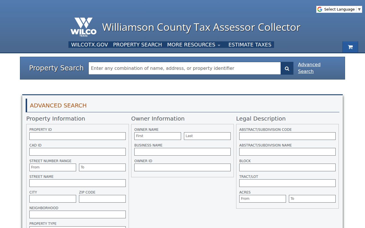
After a result appears, compare it with WCAD Property Search and the parcel map. WCAD provides the taxable-owner and parcel layer, while the Tax Assessor-Collector maintains the tax-account and certificate function.
Williamson County ZIP Address Keys
A ZIP code is only one of several address keys. Postal data usually follows a mailing or delivery address. GIS uses coordinates and parcel location. A recorded deed is indexed by parties and legal description. Voter information is tied to registration residence and carries confidentiality limits. A person can own one parcel, receive notices at another address, and appear in a different postal pattern. Read the field label before drawing any conclusion from an address match.
- ZIP code
- A postal-delivery area, not a municipal or county boundary.
- ZIP+4
- An added four-digit delivery detail used with a five-digit ZIP.
- PO-box ZIP
- A postal code associated with post-office box delivery rather than proof of a physical parcel location.
- Unique ZIP
- A ZIP assigned to a single organization or use, when the postal service designates one.
- Carrier route
- A delivery route grouping that is different from city, precinct, and parcel boundaries.
County guidelines define a street address as the official number and terms that identify a unique property along a road. They also state that city or county assignment depends on where development lies. A road can retain the same name across a city line, which helps an address search but does not turn the ZIP into a boundary record.
Williamson County ZIPs Are Not City Limits
Several local edges make postal labels misleading. ZIP 78717 is an Austin postal area with a Williamson County edge. The county portion of 78660 relates to Pflugerville, while 78653 reaches the southeast edge near Manor and Pflugerville. ZIP 78646 serves north Austin technology-corridor portions, and 78645 crosses a lake-area county and city context. These are normal postal-geography outcomes, not errors in a property record.
Boundary check. Match the verified postal address to the county GIS result, then compare the parcel’s situs and legal description before choosing a local office or record source.
The county’s Addressing Guidelines describe the official 9-1-1 address data and emergency service zones. They are more useful for a jurisdiction question than a broad postal city label.
Williamson County ZIPs and Precincts Change
ZIP geography should not be treated as election geography. Williamson County’s Maps page records voting-precinct changes effective January 1, 2026, connected to the 2025 congressional-boundary plan adopted by Commissioners Court on October 28, 2025. An older precinct number can therefore reflect a redrawn election boundary instead of an address move. Date the result and use the county voter lookup only for its limited registration and polling-place function.
Texas Election Code restrictions protect voter identifiers and suppress qualifying addresses and other fields. A ZIP-filtered property result and a voter record do not answer the same question. Keep the systems separate, and use a written Texas Public Information Act request when a county-held record is unavailable online. Note: Postal, parcel, and precinct records should be compared by their own dates and purposes.